I’ll admit it upfront, I’m a bit of a map addict. I have an obsession with landscape and habitats and can spend hours studying distribution map of birds and butterflies – and, of course, lichens. As I started out, I took those maps as given, a reflection of the real distribution of lichen species in North-East Scotland, but I have increasingly come to question the extent to which these distribution maps reflect the actual distribution of lichens in the field.
The British Lichen Society uses three colours to indicate the date of the most recent record of a species: green for records from between 1650 and 1959, blue for records found between 1960 and 1999, and red for species found since the year 2000. This map of the distribution of Cornicularia normoerica shows records found in each of these periods. Indeed, lichens are long-lived and so it could well be that a species found in 1960 is still present in 2022, but with changes in land use, changing pollution levels and climate changes that is not a given. And it is not always clear whether a hectad (a 10 x 10 km square on an OS map) is blue because it was between 1960 and 1999 that a species was last found there, or because nobody has returned to the area since 2000 to check whether the species is still there. Even more fraught with difficulty is the interpretation of the absence of a coloured square in an area. Does that mean the species genuinely does not occur in the area or that nobody has ever looked for it?
This is what I know has happened in Kincardineshire (VC91), Aberdeenshire, where I have done a significant amount of my recording to date. In the late 1960s and 1970s each of the hectads in this vice county were visited by the famous lichenologist Ursula Duncan and fellow lichenologists. In a systematic manner they visited one site in each hectad, with an apparent preference for the coastline, churchyards and dykes. Since then, the vice county has been visited occasionally by other lichenologists who seemed to have had a preference for the road over the Cairn o’ Mount and through Glen Dye. The only area that has been given more elaborate attention by lichenologists in recent decades was that around Edzell, where the famous gorge, the Rocks of Solitude and the neighbouring estate grounds of The Burn have been surveyed in detail. Marking the exact locations that have been surveyed on a map suggests that no lichenologist ever visited the conifer plantations that cover the northern half of the vice county. I have always felt attracted to these mature conifer plantations, not least because of the hidden stone circles, abandoned farmsteads and pockets of broadleaved woodland these plantations contain. Fifty years ago, Ursula Duncan and co-workers never visited these plantations, which may well be because they had just been planted and presented themselves as oppressive and impenetrable young spruce plantations. Had there been records of that time, my records of the last few years may well have shown increased lichen diversity, reflecting the maturing and subsequent diversification of those plantations.
The accuracy of distribution maps is not only reliant on whether we visit an area, but also the approach we take to collect records. Perhaps not surprising for a map addict, I am also a keen walker. No, not that kind of walker that need the hills, but one that strolls and rambles local fields and wood several times a week, exploring or revisiting paths, looking at the habitats and trees along on the way, following the dykes that line fields. Some months my rambling searches out stone circles indicated on maps, other months I follow the river Dee to look at aquatic lichens. The lists of lichen species seen while out walking tend to be more diverse and longer than those that I collate when recording in one limited area close to a road. The act of walking often involves walking away from areas easily accessible by car and almost unequivocally allows for an encounter with a wider range of habitats and substrates and hence more lichen species. As I have been studying maps and walking the landscape ever since I moved to North-East Scotland seventeen years ago, I have developed an intimate knowledge of the landscape that is based on a detailed understanding of the habitats and substrates available to lichens. By revisiting hectads again and again, but looking at different habitats and substrata, I have developed a multi-layered picture of the lichens present.

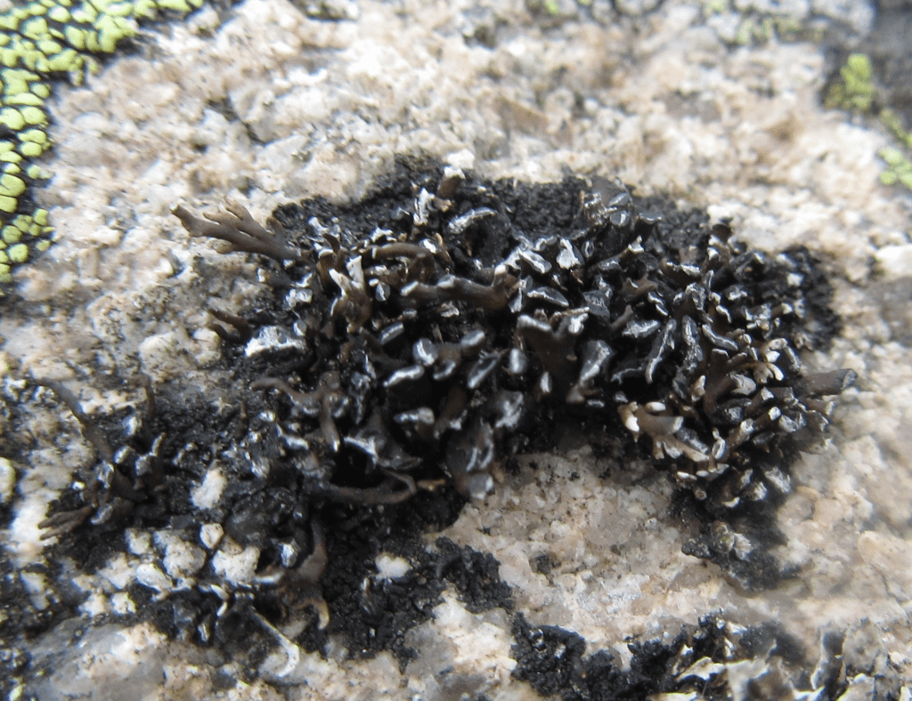
And intimate knowledge of the local landscape pays off. When I explored the branches of a few hazel trees on the slopes above a burn no more than a mile from home, I was surprised to find Hypotrachyna revoluta, a species that only had one or two other records in NE Scotland. On a stone circle and nearby dyke in the conifer plantations near Strachan, I found Mycoblastus sanguinarius, a species that had not been recorded previously in Kincardineshire. Likewise, a dreich Saturday afternoon stroll up the Barmekin of Echt, a hillfort on a low hill surrounded by farmland, revealed Cornicularia normoerica, a species usually found only further west in the hills of Deeside.
When walking my local landscape I often think of the mammoth effort by Pete Martin in Cumbria who, during lockdown, made a detailed record of the lichens in each of the hundred 1 x 1 km squares in the hectad where he lives. And in a quest to update and extend the lichen distribution maps for Cumbria, his fellow members of of the Cumbria Lichen and Bryophyte Group Caz Walker and Chris Cant visit the fells and limestone outcrops in an attempt to refind historic records of upland species. The lichens you find in a landscape are dependent on the substrate available and environmental conditions. What we share is an understanding that changes in land use, pollution levels and changes induced by climate change may bring about changes in the lichens we find around us. Each blue square we turn red indicates continuity, but squares that remains blue, and squares that turns newly red pose questions may trigger questions as to the health of our environment. It is rainy today, a good time to unfold that map.
***
If you are interested in lichen recording and would like help with lichen identification, there are a number of useful Facebook groups where you can get help with identification, including Scottish Lichens, Cumbria Lichens and Lichen Spotters UK. In addition to this, the websites Scottish Lichens and Dorset Nature provide photos and species descriptions for selected species. The standard guide used for lichen recording is the 2018 edition of Frank Dobson’s Lichens – An Illustrated Guide to the British and Irish Species. For instructions on where and how to submit lichen records, please see the website of The British Lichen Society.
Copyright text and images Petra Vergunst
